

Chulu East West Peak Climbing
Overview
Trip Information
Chulu East-West Peak Climbing (6,419M/21,054FT) Adventure Pilgrims Trekking has experience climbing guides who will take you to summit the top of the worlds but for the beginner of the climbing with technical support with our staff, you will be in the top of the Chulu west peak.
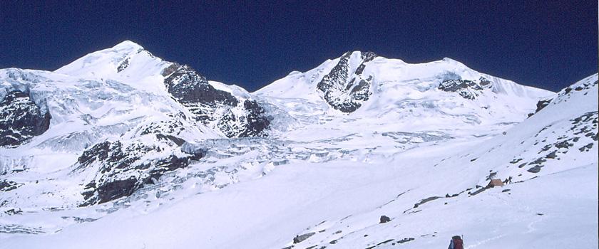
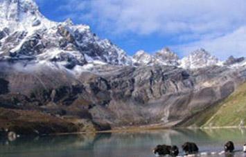
These peaks are part of the Manang Himal, which are quite rightly included in the larger Damodar Himal, the eastern limit of which runs south from Chako and Peak 6687 in a north-to-south direction along the Hunlung Khola, Nar Khola, and Phu Khola. To the south, it is bounded by the Marsyangdi Khola and the Mesokanta La. There exists considerable confusion with regard to the name and location of the Chulu peaks and what summit actually constitutes Chulu West and Chulu East, since it soon becomes apparent to anyone that has climbed in the range that several other summits close by, which are actually part of the Chulu massif, are not indicated on present maps of the area. For the sake of clarification, four summits can be included in the Chulu group, two of which are possible on the permit for Chulu West and two on the Chulu East permit. What is apparent is that the available trekking map is highly misleading.
The highest of these peaks marked Chulu West (6419m/21,054ft) on the trekking maps, has a recorded altitude from at least two expeditions of nearer 6400m (20,997ft); this might more accurately be called Chulu Central. As a result, many climbing parties have mistakenly climbed one of these peaks thinking it to be Chulu East or West. It usually understood that with the permit to climb the East or West peak an attempt can be made to the nearby peak as well.
A climb of one or both of these peaks combined with Nepal's most famous Around the Annapurna trek makes up for one of the most spectacular Himalayan trekking and climbing outings. Chulu West:
The obvious approach to this peak diverges from the main trail to the Thorung La pass past the village of Manang and Base Camp is established in a small valley to the North. From base camp, the route follows a subsidiary North-West ridge that leads up to the main peak. An attempt to the peak and return has been done in a single day as setting camp up on the slope above base camp is not easy. An attempt of Chulu Chulu West Peak Climbing in Spring.
Detail Itinerary
Day 1 : You drive along the Kathmandu-Pokhara Highway to Dumre and then follow the narrow and paved road by the Marsyangdi River to Besi Sahar (823m.). It takes almost six hours. Beshishahar is the district headquarters of Lamjung district. All the local government offices are situated here. From here, you can see some of the mountain peaks, natural Sceneries surrounding the valley and the daily activities of local people. This headquarters is the center from where the daily usable commodities are supplied to the different villages and numerous towns.
Day 2 : Trek from Beshishahar to Bahundanda (1305m.) and it takes about six hours. The first part of the trail passes on a flat level along the bank of the Marshyangdi river. You can enjoy the Sceneries and the local culture of the Gurung community. After lunch, the trail goes steeply upwards to Bahundanda which takes about 2 hours. At this point, you can see the area surrounded by eye-catching scenarios with snow capped mountains.
Day 3 : Trek from Bahundanda to Chamje (1410m.) which takes about six hours. A steep trail descends for early half an hour and then follows flat path through rice terraces, before crossing a stream at the bottom of a small waterfall. It then climbs again and traverses the hillside high above the river before reaching the village of Lali Gaon. Ahead, the Marsyangdi valley forms a steep V-shape, and you follow the winding mountain path down through Syange (1100m.) where there is a beautiful waterfall above and along the river for some distance. The trail then climbs steeply and the path is cut into the sheer cliff-face some 200-300m above the riverbed. Eventually, you descend to the stone village of Jagat (1330m.) situated on a shelf which juts into the precipitous Marsyangdi valley. Now the trail begins to observe small ups and downs to Chamje through the forests.
Day 4 : Trek from Chamje (1410m.) to Dharapani (1960m.) and it takes about six hours. The first part of the trail descends to the river and after crossing a suspension bridge, you begin a climb to Sattale (1550m.) on a path so steep that it seems one slip would send you hurtling down into the valley. You continue on an undulating path above the river, and at one point, where a tributary flows in from the opposite bank, the main river becomes covered with huge boulders that hide the water. Climbing the zigzagged path to the top of the hill, you see the level plain of Tal (1700m.) before us. Though it is enclosed by cliffs, the level area looks reassuring after the harrowing mountain paths just traveled on. You descend to a grassy riverbank which leads to Tal with its hotels and Tea houses. Beyond Tal, the valley narrows and the path becomes high and winding, and in several areas Hewn from the rock itself. Beyond the small village of Karte (1900m.), there is a bit more cliff-walking before the path drops again to the river. You cross a suspension bridge, and climb the short distance to the stone Kani marking the entrance to Dharapani (1960m.), and our camp for the night.
Day 5 : Trek from Dharapani to Chame (2675m.) which takes about five and half hours. As you cut through a narrow field from the village, the Dudh Khola, which originates from the south face of Manaslu, enters on the opposite bank. The Marsyangdi then veers to the left, and as Annapurna II becomes visible ahead, you arrive at Bagarchhap, a Bhote village with prayer flags fluttering in the breeze around a Buddhist monastery. Continuing to climb through forests of pine and oak, you pass through Danaque (2210m.). From here comes a small wooden bridge which takes you to follow a steep ascending path up to Timang. It lies at the bottom of Lamajung Himal. The trail goes through flat level until you reach Chame where there are government offices, shops, and hotels. Chame is the administrative headquarters for the Manang district.
Day 6 : Trek from Chame to Pisang (3100m.) which takes about five hours. With Lamjung Himal (6893m) sparkling in the morning sun, you set off for Pisang. The mountain disappears as you climb the path up the valley, passing a huge apple orchard. You continue through a fir and pine forest, climbing to a high, rocky area as the opposite bank becomes an impassable cliff. From this point the valley becomes extremely steep-sided as you follow the path to Bhratang (2950m.).In the past this was the military station for troops who fought against the Khampa tribal revolution, but the dilapidated buildings are all that remain of that era. A short climb from the village brings you to a rock-strewn area where you cross a wooden bridge and follow a high, winding path, before crossing back to the right bank again. You now walk through a pine forest and as the forest ends, the valley changes from a V-shape to a gentle U-shape, opening up a wonderful vista before you. You can see the east peak of Annapurna II as well as Pisang Peak (6091m.) to the north-east. Continuing on, you come to a long Mani wall by a bridge and the lower village of Pisang.
Day 7 : Trek from Pisang to Manang (3440m.) and it takes about five and half hours. Beyond Pisang, the trail climbs a steep ridge which affords good views of the Manang valley and Tilicho peak (7145m.). Descending past Manang's airstrip at Hongde (3320m.), you come to a level area from where the north-east face of Annapurna III rises majestically above you. From the wide plains of the Sabje Khola Valley, Annapurna IV (7525m) also becomes visible. Just beyond this point you cross the considerably reduced flow of the Marsyangdi Khola via a wooden bridge to the tiny village of Mungji. Cultivated fields appear on both sides of the path and off to the right, below a craggy mountain, you can see the village of Bryaga with its splendid monastery. Large Chortens and Mani walls abound and the tall peaks of the Himalaya spread out before you - Annapurna II, Annapurna III, Annapurna IV, Gangapurna (7455m) and, to the rear, Tilicho Peak [7145m].
After a short steep climb you reach Manang which is a surprisingly large village for this remote mountain region. You camp here for the night, amidst the fluttering prayer flags which adorn the houses.
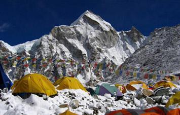
Day 8 : Rest day at Manang and hang in and around town. This is an important rest and acclimatization day today before crossing the Thorung La. There are optional day walks such as crossing the river to see the tremendous Ice Fall coming down from the Annapurnas, or climbing high above the village for a full panorama of the Annapurna range and the Manang Valley. There is also a Himalayan Rescue Association [HRA] aid post in the village which makes an interesting and educational visit. Moreover you can visit Ganagapurna Glacier Lake to make your rest day a memorable one.
Day 9 : Trek from Manang to Yak Kharka (4350m.) and it takes about three and half hours. Now the trail ascends gently all the way to Yak Kharka passing through the Gunsang (3960m.) village. En route, you can see panoramic views throughout the day.
Day 10 : Trek from Chulu West Base Camp to Chulu West High Camp and it takes about three hours. The path is steeply up all the way. En route you can enjoy the panoramic views of Annapurna range and Chhulu West.
Day 11 : Climb Camp I (5400m).
Day 12 : Climb Chulu West (6420m.) and return back to Chulu West High Camp
Day 13 : Trek from Chulu West High Camp to Chulu Letdar (4200m.) which takes about four hours. You descend all the way to Chulu Letdar. Again you are greeted with beautiful views of the Annapurna range and Chulu West.
Day 14 : Trek from Chulu Letdar to Thorong High Camp (4800m.) and it takes about five hours. Until Thorong Base camp the path is rocky and you trek on a gradually ascending path. Afterwards, the path is steeply up to Thorong High Camp.
Day 15 : Trek from Thorong High Camp to Muktinath (3850m.) via Thorong La (5416m.) Pass and it takes about eight hours. You start early today for your crossing of Thorong La [5416m]. The trail becomes steep immediately on leaving camp but as this trail has been used by local people for hundreds of years the path is well defined. The gradient then eases and after around 4 hours of steady climbing you Reach the Chorten and prayer flags of the pass. The views are dramatic to say the least, from the snow-covered mountains above, to the head of the Kali Gandaki valley below and the brown and purple hills of Mustang which are spread out before you. The descent to Muktinath is a knee pounding 1600m but it's compensated for with excellent views of Dhaulagiri. Eventually the moraines give way to grassy slopes before a pleasant walk along the Jhong Khola Valley to Muktinath and its shrines and temple.
Day 16 : Trek from Muktinath to Tato Pani with bus/ jeep sharing drive via below places .
Kagbeni (2895 m.) to Marpha (2650m.) to Kalopani (2530m.) to Tatopani (1189 m.) which takes about 7 and half hours. You can enjoy the hot spring at Tatopani, as the word Tatopati is termed after the natural hot spring situated at the bank of the Kali Gandaki river. It is popularly believed that taking bath in Hot Spring helps you to get rid of skin diseases. Along with this, it also gives you physical and mental refreshment.
Day 17 : A rest day at Tatopani to enjoy the natural hot spring bath. After several days trekking, it is a great idea to take bath at hot spring and relax.
Day 18 : Trek from Tatopani to Ghorepani (2853 m.) for about seven hours. Your trail passes on flat land for some distance. Then the trail begins ascending steeply for at least one hour. Now the path goes up through different villages inhabited by the people of different castes and agricultural land. The majority of the people here serve in the Gorkha Regiment and Indian Regiment as well. While trekking, you cross through the Kali Gandaki river with panoramic view of Dhaulagiri and the Annapurna range. The trail ascends gently all the way to Ghorepani passing through small villages like Phalate, Chitre and so on. While trekking you pass through rhododendron forests and come across wild life such as monkeys and various species of birds. You are also accompanied by more panoramic views of different mountains. Ghorepani (Watering to Horse) is a small pass and the village of Deurali. Although there is time enough to continue, it is better to stay here overnight so that you can make the morning trip to Poon Hill (3180m.) for an outstanding panorama of Dhaulagiri I,II,III,Iv, Tukuche peak, Dhampus peak, Nilgir ranges,Annapurna I, Bahra Sikhar (Twelve peaks or renowned as French Fang),Annapurna South, Himchuli, Fishtail and Mardi Himal. The view you can see from here is probably the best view in the world. Because of this, Poon Hill is often crowded by different visitors to enjoy the sunrise and sunset over the snow-capped mountain
Day 19 : Trek from Ghorepani to Poon Hill (3180m.) to Hille (1475m.) which takes about five hours. Early morning trip to Poon Hill (3232m.) to enjoy the sunrise view over Mt. Dhaulagiri (8167m.), Tukuche Peak (6920m.), Nilgiri (6940m.), Varaha Shikhar (7847m.), Mt. Annapurna I (8091m.), Annapurna South (7219m.), Annapurna III (7855m.), Machhapuchhre (6993m.), Annapurna IV (7525m.), Annapurna II (7937m.), Lamjung Himal (6931m.) and other numerous Snowcapped mountain peaks. After breakfast, you again follow a gradual descending path through the forests of rhododendron and oak to Banthanti. It is a small village where you can pause for hot and cold drinks. Then the trail descends to Ulleri (1960m.), a big Gurung village from where you can enjoy views of Annapurna South, Machhapuchhre and Hiunchuli. From here, the trail to Tirkhedhunga steeply descends passing terraces and some villages. After a short walk of 15 minutes from Tirkhedhunga, you reach Hille. It is also a small Gurung village with surrounding green hills. Most of the inhabitants of this village are occupied in agriculture.
Day 20 : Trek from Hille to Nayapul (1050m.) via Birethanti and it takes almost three hours and drive from Nayapul to Pokhara which takes about one and half hours. This day’s trek gradually descends following Bhurung Khola (Bhurung Stream) all the way to Birethanti before you cross the Modi Khola over the suspension bridge. You are amazed to pass small villages, see the magnificent waterfalls and walk through the sparse forests.
Day 21 : Drive from Pokhara to Kathmandu by tourist mini bus that takes about seven hours. While driving from Pokhara to Kathmandu, you head up to Damauli,, Dumre, Muglin and Kurintar where Nepal's first Cable car is operated to reach to Manakamana Temple. En route, you can enjoy the mountain views, green Sceneries, rice terrace fields, vegetable fields and people being engaged in their daily life activities. From Naubishe you climb up to Thankot, the gateway to the capital city. Or you can also fly from Pokhara to Kathmandu which takes about 25 minutes.
What's Included
Included in the Cost
- Camping Trek Includes
- 4 nights hotel in Kathmandu with 3 star bed and breakfast
- Permit fee of Chulu West 6519m. Peak
- Equipment: Trekking tents, Dining tent, Kitchen Tent, Toilet Tent, Table and chairs, Mattresses during the trekking and Peak climbing period
- Food: Food for trekking and Peak climbing( Breakfast, lunch, dinner)
- Staff: 1 Base Camp Guide, 1 Cook, 1 Kitchen, 1 climbing guide and necessary porters
- Local transportation Airport-Hotel-Airport
- Kathmandu-Besisahar and Pokhara-Kathmandu by tourist bus
- Park fees of Annapurna region
- Trekking crews insurance
- Trekking allowance, food allowance for trekking crews
- Farewell dinner
- Our service charge
- Lodge Trek (Tea House) Includes
- 4 nights hotel in Kathmandu with 3 star bed and breakfast
- Permit fee of Chulu West Peak
- Meal: All meal during the trek best available hotel/lodges or tea house
- One experience trekking guide/Climbing Guide and necessary porters
- Park fees for Annapurna region
- Kathmandu-Besisahar and Pokhara-Kathmandu by tourist bus
- Insurance for Guide and Porters
- All accommodation during the trek best available hotel/guesthouses
- Airport-Hotel-Airport transfer
- Farewell dinner
- Our service charge
Not Included in the Cost
- PERSONAL equipment for climbing and Trekking
- Personal Insurance for travel to Nepal
- Climbing food
- Lunch and dinner in Kathmandu
- Emergency Rescue evacuation in case needed
- Trekking Sleeping bag and Jacket
- Personal expenses
- Tipping (Tips)
- Bar bills and Beverage
- Departures taxes for International flight
- Please inquiry about it for customized climbing trip.
Trip Fact
- Duration: 21 Day(s)
- Trip grade: Adventure
- Activities: Peak Climbing
- Group size: Min 1
Nepal travel information
SIMILAR TRIPS
People who viewed this tour also like...


Adventure-Pilgrims-Trekking-Pvt-Ltd-Nepal